Brigade Innovation Gardens KIADB — Master Plan and Site Layout
No sanctioned master-plan drawing has been released for Brigade Innovation Gardens, and no brochure plate exists. What does exist is unusual for a project at this stage: a dimensioned land-use declaration, filed with the state and cleared by it. The Environmental Clearance granted by the State Environment Impact Assessment Authority, Karnataka on 25 November 2025 — EC Identification No. EC25B3812KA5293680N, File No. SEIAA 120 CON 2025 — fixes the site area, the built-up area, the Floor Area Ratio, the open and planted area, the paved surface, the parking area and the land set aside for sewage treatment and solid waste. This page reads the site plan out of those figures, and is explicit about where they stop. For another Bengaluru planning reference, Brigade Old Madras Road helps keep attention on density, circulation, landscape depth, and the way residents will move through the community.
The parcel is Plot Nos. 305-309, 2nd Phase, KIADB Hi-Tech Defence and Aerospace Park, Haraluru and Muddenahalli Villages, Channarayapatna Hobli, Devanahalli Taluk, Devanahalli, Bengaluru Rural District, Karnataka 562110. Brigade Innovation Gardens is being developed by Brigade Group, through its wholly owned subsidiary Tetrarch Developers Limited — the project proponent named on the Environmental Clearance granted by SEIAA Karnataka on 25 November 2025. The application is filed under the name Brigade Integrated Mixed Use Development.
Brigade Innovation Gardens site plan
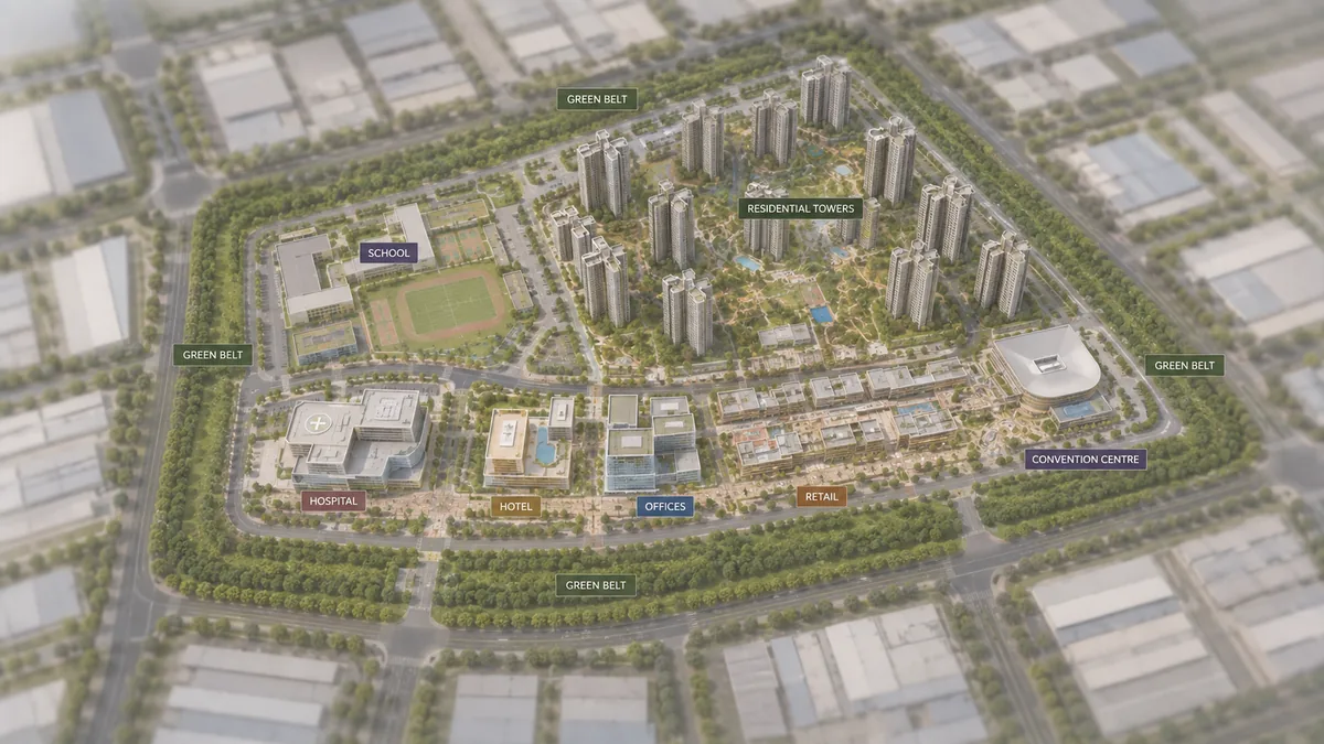
The land-use breakdown recorded for Brigade Innovation Gardens
| Element | Area | Share of the 303,687.64 sq.m site |
|---|---|---|
| Total land area | 303,687.64 sq.m (75.04 acres) | 100% |
| Total built-up area | 1,905,313 sq.m at FAR 3.25 | — |
| Open area | 100,217 sq.m | 33.0% |
| Paved area | 91,106.3 sq.m | 30.0% |
| Unpaved area | 91,106.3 sq.m | 30.0% |
| Green belt | 30,368.77 sq.m | 10.0% |
| Surface parking area | 15,185 sq.m | ~5.0% |
| Sewage-treatment and solid-waste zone | 5,000 sq.m | ~1.6% |
Three things about that table are worth saying plainly rather than smoothing over.
The rows are not slices of one pie. Green belt plus paved area alone comes to 121,475.07 sq.m, which is already more than the 100,217 sq.m recorded as open area, and the full column sums well past the parcel. These are separate declarations made in different sections of one application form, each certifying a different commitment. Read each row for what it commits to, not as a share of a single partition.
The paved and unpaved areas are entered at the same figure. The application records a paved area of 91,106.3 sq.m and an unpaved area of 91,106.3 sq.m — the identical number in two adjacent fields. We publish both as recorded rather than pick one, because there is no basis in the document for choosing. If the sanctioned layout resolves it differently, the sanctioned layout is the one to trust.
Every figure resolves to a round percentage of the plot. 33 per cent of 303,687.64 sq.m is 100,216.92, and the record says 100,217. Thirty per cent is 91,106.29, and the record says 91,106.3. Ten per cent is 30,368.76, and the record says 30,368.77. That reads as a set of design targets declared against the plot area rather than areas measured off a drawn plan — which is what you would expect from a clearance obtained before a layout is sanctioned. It makes the numbers commitments, and commitments are checkable later.
What is FAR in real estate, and what FAR 3.25 means on the Brigade KIADB master plan
Floor Area Ratio is the ratio between the floor area a development may build and the area of the plot it sits on. At a FAR of 1.0, a plot supports one square metre of floor for every square metre of land. At a FAR of 3.25 it supports three and a quarter times the plot area. It is set by the planning authority for the zone and the road width, not chosen by the developer, and it is the single control that decides whether a given number of homes arrives as low-rise sprawl or as towers with ground left over. Two things it is not: FAR is not the same as ground coverage, which limits the footprint rather than the total floor area, and it is not a measure of saleable area, because what counts toward FAR and what a buyer is charged for are defined differently.
Worked on this site: 303,687.64 sq.m of land at a FAR of 3.25 gives about 986,985 sq.m of FAR-countable floor area. The application separately records a total built-up area of 1,905,313 sq.m — roughly 20.5 million sq ft. The difference of about 918,000 sq.m is the part FAR generally does not count: basements, parking levels, service floors and plant. The split between countable and non-countable area is not published in any source, so the 986,985 sq.m figure is our arithmetic on two confirmed inputs and not a number lifted from the document.
The practical consequence is the shape of the township. The same FAR-countable floor area at a FAR of 1.75, which is closer to what a plotted or low-rise Devanahalli scheme works with, would need roughly 139 acres of land instead of 75.04. Brigade Innovation Garden is planned the other way: a compact building footprint, height where the density goes, and about a third of the parcel held open at ground level.
Building placement across the 75.04 acres
The clearance records 7,195 dwelling units on 75.04 acres — about 95.9 dwelling units per acre, our arithmetic on the two confirmed inputs. That is a high-density plan by Devanahalli standards. It sits close to Provident Ecopolitan's roughly 90 units per acre in the same belt, and a long way from Birla Trimaya's 39 or Tata Carnatica's 12, which are low-rise and villament formats on the airport's western side. Density is the number that most shapes what a master plan can look like, and 95.9 per acre only works vertically.
The built form on record is towers with 1 to 4 basement levels plus ground plus 1 to 30 upper floors, against a separately stated maximum of 35 floors. Both statements appear on the same application. We publish the height as up to 35 floors and describe the structure as the document describes it; the two are not reconciled in the source and we are not going to reconcile them here.
The programme those buildings have to hold is wider than a residential project. The clearance lists residential, industrial flatted factory, warehouse, logistic, retail mall, commercial offices, hotel, hospital, school, convention centre, cultural centre and visitors centre, including a 300-bed hospital and a 500-key hotel. Every one of those is an approved component of an application, not a delivered or operating facility, and the construction window runs to 2035.
Where those components sit is not published. No source states where the hospital stands relative to the homes, or which edge the commercial frontage takes. Any diagram that shows you those placements today has invented them.
Green belt and open space at Brigade Innovation Gardens
| Commitment | Figure |
|---|---|
| Green belt | 30,368.77 sq.m — 10 per cent of the site |
| Open area | 100,217 sq.m — 33 per cent of the site |
| Saplings | 3,800 |
| Plantation allocation | Rs 10 lakh |
A green belt in a clearance is a planted area committed to the authority. It is not the same thing as a landscaped amenity garden, and the application does not say where on the parcel it runs. The 3,800 saplings across 30,368.77 sq.m work out to roughly one sapling per eight sq.m — dense planting by the standards of a perimeter belt, which suggests a genuine canopy rather than token verge planting. The Rs 10 lakh plantation allocation across 3,800 saplings is about Rs 263 a sapling: that is a planting-stock and establishment allocation, not the landscape construction budget for a 75-acre township, and it should not be read as one.
The 100,217 sq.m of open area deserves the same care. Open area on a clearance is the land not carrying building footprint. It includes driveways, fire-tender paths, hardstanding and service yards as well as lawns and gardens. Read it as the measure of how compact the footprint is, not as 100,217 sq.m of usable garden.
Roads, entries and circulation
The site sits inside a serviced industrial estate rather than on raw land, and the application states that wide roads, electricity, water, sewer and drains are readily available at the plot. That is a material difference from a greenfield township that has to build its own trunk services to a boundary.
On the township's own circulation, the application records multiple entries and exits, bell-mouth entry and exit geometry, and security-managed access. A bell-mouth is the flared throat at a gate that lets an arriving vehicle clear the public carriageway before it stops — the detail that decides whether a 7,195-home development queues its residents onto the estate road at peak hour. A dedicated Traffic Impact Assessment is listed among the documents submitted with the application. The extracted application text records a volume-to-capacity ratio of 0.07 and level of service 1 for one assessed link; that is a single link under today's traffic, before this township exists, and it is not a forecast of what the finished development will generate.
The exact internal road hierarchy, carriageway widths and peak-hour project traffic are not in the record. Those belong to the full Traffic Impact Assessment and the sanctioned layout, and no number should be quoted for them until one of the two is public.
Arrival, measured by routing on the road network from the site pin at 13.215801, 77.765376 rather than taken from the clearance, which carries no distances at all: the KIADB internal grid connects the parcel to the Satellite Town Ring Road (NH-648) about 2.3 km away, and the park centroid routes at about 1.2 km. One caveat — the internal road segment the pin sits on is still tagged as under construction in OpenStreetMap as of August 2026, so the immediate approach is being built out alongside the project.
Pedestrian movement and landscaping
The clearance is a statutory environmental document, not a landscape drawing, and it says nothing about walkway networks, tracks or plazas. It does commit to the frame those things sit in — the green belt and open-area figures above — and to one detail that shapes the landscape more than it first appears: dual plumbing carries treated water to landscape irrigation, so irrigation mains run to planted areas as part of the base infrastructure rather than as a later addition.
Tree-lined internal avenues, pedestrian walkways, jogging and cycling routes through the green belt, children's play areas, an event lawn and a residential clubhouse are all reasonable expectations for a township of this format, and they are planned features rather than recorded ones. No size, count or dimension has been published for any of them, and nobody should quote one.
Three questions are worth holding until the sanctioned layout appears. Whether pedestrian movement is separated from vehicle movement at grade. How far a tower core stands from the school, the retail and the hospital blocks, because on a 75-acre parcel those walks can be long. And whether the green belt runs as a continuous loop or is broken into fragments between blocks, which is the difference between a walkable landscape and a set of planted gaps.
Below-ground infrastructure
The plan goes as deep as four basement levels — the application describes 1 to 4 basements beneath the towers, which is where the bulk of parking will sit. The 15,185 sq.m recorded for surface parking is an area, not a bay count. No parking-bay count exists in any source for this project, and any figure quoted elsewhere is invented.
Two site conditions on the record bear directly on that excavation. Groundwater was not intersected at the site, which for a plan digging four levels down is a favourable finding. The soil is recorded as clay, which matters in the other direction: clay drains slowly, and the 150 rainwater recharge pits committed across the site have to work against that, as does any storm-water design. The application records 19,053 TPA of construction and demolition waste, to be reused for backfilling with the balance going to authorised agencies.
Below ground the township also carries two separate water distribution networks rather than one, because dual plumbing keeps treated recycled water for flushing and landscaping apart from fresh supply. The KIADB estate provides the sewer and drain connections those systems terminate into.
Sustainability infrastructure and where it sits on the plan
| Element | Provision |
|---|---|
| Sewage-treatment and solid-waste zone | 5,000 sq.m of the site — about 1.6 per cent |
| Sewage treatment | Sequencing Batch Reactor plant |
| Treated water reused on site | 7,776 KLD of 8,640 KLD generated |
| Rainwater harvesting | 7,500 cu.m rooftop collection sump plus 150 recharge pits |
| Rooftop solar | 2,000 kW |
| Organic waste | 12,962.245 TPA composted on site |
The land-use reading is that the utility programme has its own address on the plan rather than being fitted into leftover corners. The 5,000 sq.m zone has to hold both the Sequencing Batch Reactor plant and the composting operation that processes 12,962.245 TPA of organic waste — roughly 35 tonnes a day, needing floor area, vehicle access and a buffer from homes. The 7,500 cu.m sump and the 150 recharge pits are distributed across the site rather than concentrated, and 2,000 kW of rooftop solar commits a meaningful share of the township's roof plates to panels rather than to terrace amenities.
The reason the recycling programme is designed this hard is worth stating: the site sits in a groundwater block officially classified as Over Exploited, so on-site treatment and reuse are mitigation for a real constraint rather than a sustainability flourish.
What the master plan does not tell you yet
| Not published | Status |
|---|---|
| Number of towers, and units per tower | Not in any source |
| Ground-coverage footprint | Not published |
| Phase plan | A township this size will be phased; no plan exists |
| Position of the hospital, hotel, school, retail and office blocks | Not published |
| Internal road hierarchy and carriageway widths | Not in the extracted record |
| Parking-bay count | Not published; only a surface parking area |
| Clubhouse size and amenity dimensions | Not published |
| Apartment configuration mix | The application states the BHK mix as "Not Available" |
No possession date has been declared for Brigade Innovation Gardens. The only dated construction window on record is the Environmental Clearance application's 01 October 2025 to 30 September 2035 — a statutory construction period, not a handover date.
Brigade Innovation Gardens is not registered with the Karnataka Real Estate Regulatory Authority. No K-RERA number exists for this project as at August 2026, and any registration number quoted for it elsewhere belongs to a different project. The number will be published here on issue and can be verified independently at rera.karnataka.gov.in.
Read the clearance for what it is. It is a statutory environmental permission and it stops there: no RERA registration follows from it, no right to sell a home, no building licence. What it gives a buyer at this stage is a set of dimensioned commitments, against which the sanctioned master plan and the eventual RERA filing can be checked line by line when they are published.